GPS mapping on Lake Harriet - On the cheap

Want to get a FREE chart of Lake Harriet or Calhoun for your Garmin handheld? Read on!
OK. Several readers have noticed that I have a preoccupation with GPS and mapping. Well, guilty as charged. I used to run the Product Planning group for Magellan GPS, and I continue to work in the GPS/LBS business. So, I am always looking for a way to apply the technology to things that I love. Like sailing! Now I know that we will never get lost on Lake Harriet or Lake Calhoun, but there are still great uses for GPS on our boats.
The first is for boat speed. GPS will give you a VERY accurate reading of your speed over the ground (SOG), and because Lake Harriet has no current, that will match your boat speed all of the time. If you do not want to install a knotmeter (and drill a hole in your hull), this is a good way to go.
Second is depth and bottom mapping. Although not REALLY needed on Harriet, its fun to know how deep the water is where you are. It is a real help when thinking about anchoring. It is also very useful on Lake Calhoun, were water depth is much less consistent.
Third is a feature very dear to sailors, VMG, which is short for Velocity Made Good. It is a measure of your actual progress toward your mark, which takes into account both speed, and your beat/run angle. Garmin devices actually do something a bit less valuable to racers because their VMG is based on progress towards a waypoint, not the wind direction. But, you can trick it into giving you this and not 'cruisers' VMG.
Handheld GPS devices now run in the $200 range, and many people have them at home for other purposes, like hiking, camping, and geocaching. From a boating perspective, the real issue is the mapping. Most of the devices do NOT have marine cartography built into them, and adding it can cost hundreds of dollars. Well, there is now a free solution to that problem.
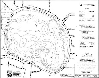
In the picture above, that depth chart of Lake Harriet was added to my Garmin Colorado at no cost! A software update to all Garmin Colorado, Oregon, and Dakota devices makes it possible to add custom map overlays to the base map. That's what I did in that example. Its free and easy, once you understand how to generate the overlay. As a service, I have created maps for both Harriet and Calhoun as well as other local sailing lakes. You can view and download them with the following links:
Lake Harriet: DOWNLOAD TO DEVICE VIEW MAP ON SCREEN
Lake Calhoun: DOWNLOAD TO DEVICE VIEW MAP ON SCREEN
Lake Minnetonka: DOWNLOAD TO DEVICE VIEW MAP ON SCREEN
Lake Waconia: DOWNLOAD TO DEVICE VIEW MAP ON SCREEN
White Bear lake: DOWNLOAD TO DEVICE VIEW MAP ON SCREEN
The maps when viewed are very large, so you might have to zoom in to see all the detail.
To use this capability, your device needs to be on the most current firmware version. Use the Garmin WebUpdater to make sure. To install the map(s), follow these steps:
1) Connect your device to your computer via the USB cable
2) The device will now attach to your computer as a USB drive. Open the drive with the file explorer
3) Open (or create) the folder \garmin\custommaps
4) Copy the downloaded files into this directory
5) Unplug and enjoy!
Don't yet have a Garmin handheld device? You can find them at Amazon HERE.
NOTE - GPS devices and these maps should never be used a singular or even primary source of navigation. You should always use prudent seamanship when using a GPS system. These maps may contain errors that would put you and your craft at risk if you use them as your exclusive means of navigating. There. I feel better for saying that!
For more information on how to generate your own custom overlays, see this LINK.
If you are just interested in paper versions of these maps, see this LINK.

Interesting. For racing, one really needs an App for a hand held that gives the speed made good towards the mark.
ReplyDeleteGot one?
All the Garmin devices (including the Colorado) have a VMG function. That's the good news. The bad news is that it is VMG with respect to a waypoint, and not wind direction, which is what sailors REALLY want.. You can fake it out by creating a waypoint several hundred miles to windward, and that has the correct effect. The device will show your SOG and VMG in two small windows on the bottom of the display.
ReplyDeleteSome devices (like the Velocitek SC-1) will split the bearing between two close-hauled tacks to figure wind direction, and then give you VMG on that. clever.